
3. An aerial view of your land
3.3. What is photogrammetry
Photogrammetry is defined by the American Society for Photogrammetry and Remote Sensing (ASPRS) as “the art, science, and technology of obtaining reliable information about physical objects and the environment, through processes of recording, measuring, and interpreting imagery and digital representations of energy patterns derived from noncontact sensor systems” (Colwell, 1997:3).
It sounds complicated and at the software processing level it is. From a user perspective its quite a simple process. What photogrammetry enables you to do, is by creating a series of overlapping images of your property, the software pattern matches each photo image to image and triangulates a series of 3D points called a point cloud. This point cloud can then be processed into a 3D model or mesh with an image of the area overlayed as a texture.
This model is both Geo located and be used to get accurate heights and volumes. It can be used to measure the size of dams or cutaways or the fall of slopes and depressions. Some services are available online that can process all the images and produce the model, a stitched orthostatic high-def image as well as geo located heights maps all from the one set up photos.
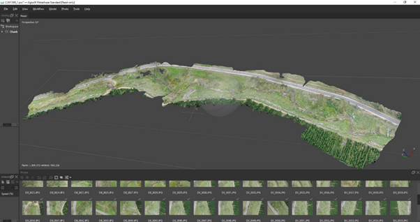
An image of a stitched orthostatic high-def image/Source: Conservation at Ecosystem Management TAFE SA
This model is both Geo located and be used to get accurate heights and volumes. It can be used to measure the size of dams or cutaways or the fall of slopes and depressions. Some services are available online that can process all the images and produce the model, a stitched orthostatic high-def image as well as geo located heights maps all from the one set up photos.
Have a look at this website by clicking on the link below to see some good examples of what can be done and what outputs to expect:
Maps Made Easy - Samples
If you haven't already subscribed to 'farmers weekly' have a look at their website to see what great information they provide. They are a US site however it still contains valuable information. Click on the URL link below:
https://www.farmersweekly.co.za/agri-business/agribusinesses/how-super-detailed-drone-mapping-is-changing-farming-forever/
Farmers who do not have a lot of
flight training can take advantage of software that can help with mission
flights. These are flights that are setup in advance over a defined mapping
area. The drone flies in a specific grid pattern, takes the photos at
pre-defined intervals and returns home when the mission is complete. The images
are them uploaded to the cloud and the maps produce. These services limit the
amount of expensive computing equipment and expertise required to produce such
output.
One note regarding photogrammetry. When creating models for terrain it works best for areas where vegetation is sparse. The process looks only at the image and note the actual ground height. It calculates the tops of plants as the level of terrain. To get an accurate level of the ground terrain, technology like Lidar would need to be deployed.
Check your knowledge using the quiz below.